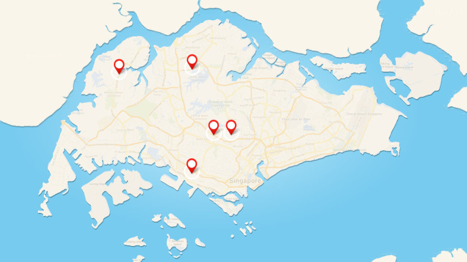
Back in 2001, the National Parks Board started the Heritage Roads Scheme, aiming to preserve the most notable scenic tree-scapes along roads in Singapore.
These Heritage Roads are rich with trees and greenery, and are excellent places to run if you want to appreciate nature while running on asphalt. In some cases, the green ambience and mature trees that line these Heritage Roads are a result of more than 40 years of care and growth!
Arcadia Road
Start: Junction with Adam Road.
End: Arcadia Road End.
Distance: 918 metres.
Located near the Botanic Gardens, Arcadia Road is a short, scenic avenue lined with mature Rain Trees (Samanea saman) that provide plenty of shade for runners. Arcadia Road was the site of an intense battle during World World 2! During the invasion of the Japanese army in February 1942, the soldiers of the 1st Battalion, the Cambridgeshire Regiment, fought hard against the Japanese army at the Adam Park Estate.
Today, Arcadia Road’s quiet atmosphere is a sharp contrast to its past. If you love to run near nature, this is an excellent running route. Start your run at the Botanic Gardens, heading 1km north along Adam Road then turn in when you see Arcadia Road. Since Arcadia Road itself is slightly above 100 metres, running to the end of Arcadia Road and back will be approximately 3.8km. If you want more distance, head into Botanic Gardens for even more sights and sounds!
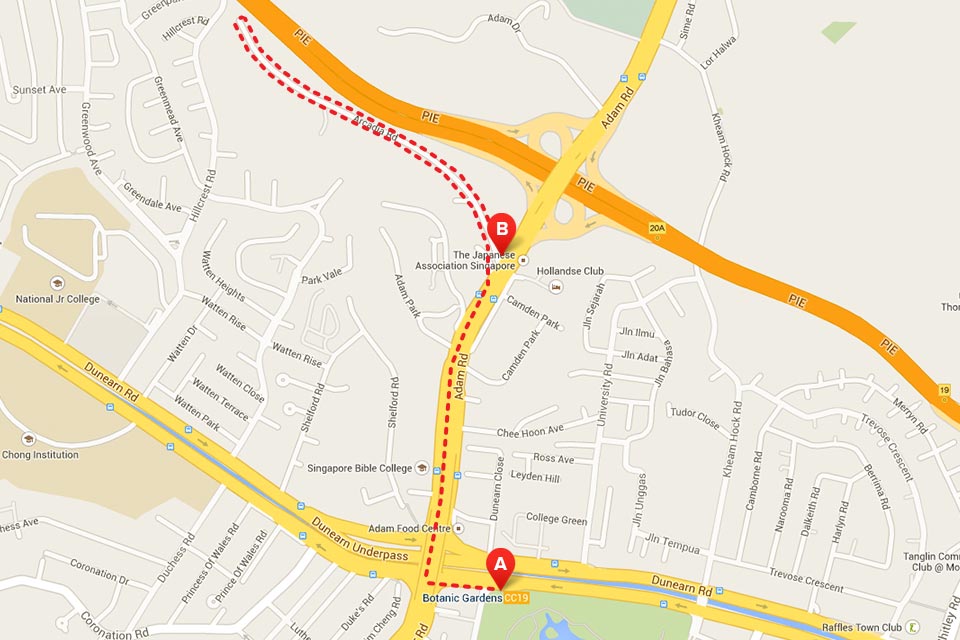
With plenty of parking space and an MRT station nearby (Botanic Gardens Station on the Circle Line), Arcadia Road is definitely one of the more convenient Heritage Roads that you can check out!
Lim Chu Kang Road
Start: Junction with Sungei Gedong Road.
End: Junction with Ama Keng Road.
Distance: 1,780.5 metres.
Lim Chu Kang Road is surrounded with lush green vegetation on both sides. It was built before the 1900s to serve the gambier, pepper and rubber plantations that once dotted the north-western countryside.
The official distance of the Lim Chu Kang Road that is designated as a Heritage Road is measured from its connection to Ama Keng Road and Sungei Gedong Road. But starting from Nanyang Avenue, you can run the entire road, heading all the north, to the Lim Chu Kang Jetty for an awesome waterfront view. The entire length of this run will be approximately 10.5km, and you can either take bus 975 back from there, or run back for a half marathon distance.
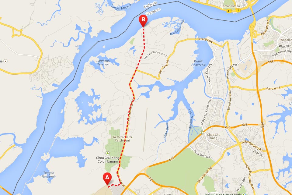
Do take care while running this route. Run in the daytime, and be sure to put on some sunscreen, insect repellent and running shades. Watch out for traffic at all times!
Mount Pleasant Road
Start: Junction with Denham Road.
End: Pan Island Expressway Sliproad.
Distance: 1,353 metres.
Curving through a hilly area of the same name, Mount Pleasant Road is a quaint housing estate with black-and-white bungalows along the road, built for the officers of the Police Force during colonial times.
Flanked on both sides with Saga Trees (Adenanthera pavonina) and their trademark bright red seeds, Mount Pleasant Road is part of an excellent 6km looped run with a gradual uphill climb.
Start from Novena MRT Station, and head north along Thomson Road. Once you run underneath the PIE bridge, turn left into Mount Pleasant Road, and continue through Mount Pleasant Flyover and Stevens Road. At Tanglin Community Club, take a left turn into Malcolm Road, running all the way to Mount Rosie Road and through Chancery Lane. Finally, you’ll see Thomson Road, and turn right to finish back at Novena MRT Station!
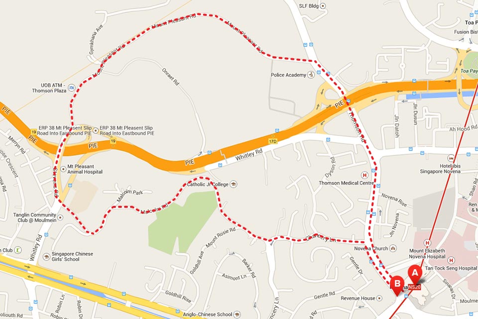
You can really see 2 sides of Singapore here. From the bustling traffic along Thomson road, the route will turn serene and peaceful run once you get to Mount Pleasant Road. Since this route starts at Novena MRT Station, it’s also extra convenient!
Mandai Road
Start: Opposite Upper Seletar Reservoir Car Park.
End: Junction with Mandai Avenue.
Distance: 1,084 metres.
Constructed in 1855, the road is surrounded by rows of mature Rain Trees and lush secondary forest. It used to serve as one of the main links between Woodlands and Upper Thomson, connecting the agriculture and poultry farming villages that are now long gone.
Unfortunately, the Heritage Road section is not too convenient for runners. But you can have a great waterside run at the nearby Upper Seletar Reservoir Park, where you’ll also find the quirky Rocket Tower!
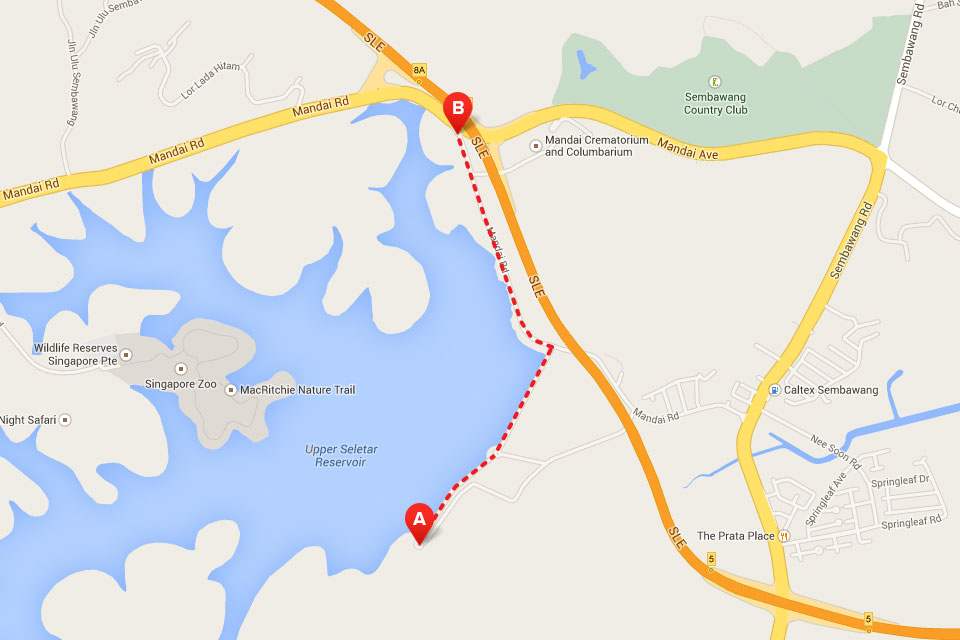
After your run, take a soothing drive down Mandai Road and appreciate the beautiful natural sights!
South Buona Vista Road
Start: Before Junction with Stockport Road.
End: Junction with Vigilante Drive.
Distance: 1,066 metres.
South Buona Vista Road is a winding road known that is nicknamed “99 Turns” for its multiple hairpin curves, and was used as part of racing circuits for cars and bicycles from the 1950s to 1980s.
You can enjoy a run that is approximately 3km in length. From Haw Par Villa MRT Station, run southeast along the West Coast Highway and Pasir Panjang Road, turning left once you see South Buona Vista Road. Follow the entire length of South Buona Vista Road (with its curves and gradual uphill ascent), and stop once you reach the National University Hospital. Kent Ridge MRT Station on the Circle line is nearby, so you can hop on the train home!
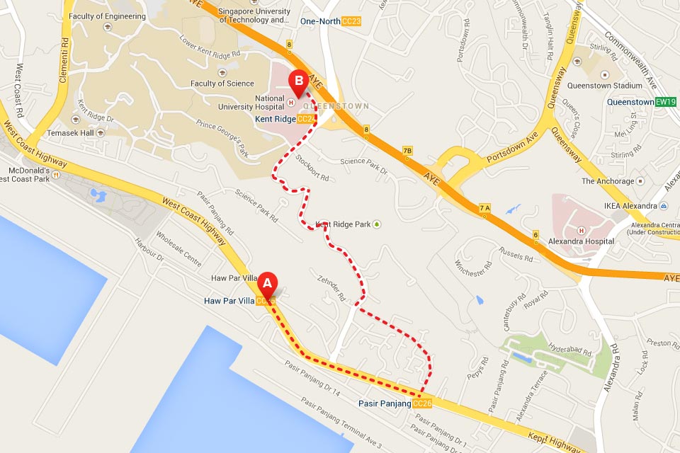
Since you never know if you’ll run into an errant car driving with a penchant for speed, run in daylight, and be aware of traffic. Take a detour and head uphill when you see Vigilante Drive, where you can enjoy wonderful views of the sea and offshore islands at Kent Ridge Park!
Enjoy the Garden City’s Tree-Lined Heritage Roads!
These 5 wonderful Heritage Roads showcase why Singapore is also known as the “Garden City”. They are also free to enjoy, and can also be a peaceful and scenic alternative to your usual running route! It gets pretty hot and humid, so remember to bring along some hydration and insect repellent too!


